|
Contact Info: Rand McNally URL: http://www.randmcnally.com/ Palm Infocenter.com Bottom Line: The Price: $199 MSRP The Pros:
The Cons:
Palm Infocenter.com Ratings*:
*Maximum Rating is FIVE (5) InfoPalms |
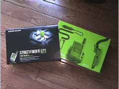
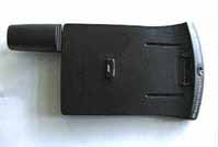
StreetFinder GPS for Palm V Robert Zach (zachr@lucent.com) 7/10/2000 Want to use your Palm to find your way? Clip on Rand McNally's GPS receiver for the PalmV and do just that! The StreetFinder GPS is an all inclusive kit containing the Palm V/Vx clip-on GPS Receiver, StreetFinder Deluxe Software, Car Mount, 12V Car Adapter, 2 AAA batteries, and a Carrying Case that will fit both thee Palm and Receiver. I was impressed at the completeness of the kit. As much as I expect this, it is getting rare these days unfortunately. As you can see below the packing is nice; very professionally done.
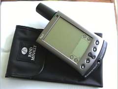
Here is a shot of the palm with GPS attached lying on top of the vinyl carry case.
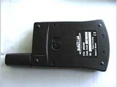
By the two shots below you can see that the style is very similar to the clip-on PalmV modem. The back of the unit has the release mechanism, battery door, and reveals the receiver componentry is manufactured by Magellan; very well known in the GPS market. On the front, the hotsync button can be used to start the satellite acquisition process. The unit will shut off after 90 seconds of no use.
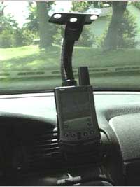
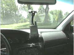
To being using the device you must first install the StreetFinder Deluxe software onto a PC. The software comes on 3 CDs - one is an install CD and the others are Eastern and Western U.S. map data CDs. The install process also has you select a user profile to install the StreetFinder.PRC file to on the PalmV (~145K). At this point you go to work with the PC software. The PC software allows you to make map snapshots or directions to transfer to the Palm. You can zoom in and out to get just the right level of detail (Rand suggests at least level 7). As you zoom in, you can see detail including POIs (points of interest) such as restaurants, hotels, schools, parks, banks, etc. This information can be included in the map information synced over to the Palm. Simply select an area and the detail level you want and click on the "MapShots" button. A map will be generated and automatically queued for your next hotsync. This process also gives you the opportunity to see map size...and these can be MONSTROUS creating long HotSync times. At this point you have a map in the Palm and you're on your way. Clip on the GPS receiver and power it on...run StreetFinder on the Palm and select GPS. Once a signal is acquired, and this can take a LOOONG time the first time (up tp 20 minutes according to the documentation), a crosshair will begin to plot your location on the map as you move. Cool! If you travel off that map, game over. Not so cool. The other mapping function you can do is address to address directions. However, this is not nearly as nice. My home was nowhere to be found on either Eastern or Western CDs, that's right the software isn't smart enough to know not to search the Western CD for an address in PA. This causes needless CD swapping. OK let's assume that you do get address-to-address directions ready, the software then goes to the Internet for the directions. Seems to me the software should be either ALL CD based or ALL Internet based, not both. This seriously hampers the "mobility" of the product. On this point I believe that a competing product, GeoDiscovery Geode, will be ALL Internet based. While I do have issues with the PC side of this application, I must say that the Palm side software has one of the slickest interfaces for a Palm app that I have ever seen. The software uses toolbars on top of the map that all can individually hide with a tap. Very Slick! Another nice feature of the Palm software is that when you first use it any tap on on the toolbar produces a dialog box that explains what the feature does. There is a check box that says "don't show this help again". I thought this was very nice, it speeds learning of the application without having to RTM ;-) The Palm app will show you where you are on a map as you travel and give very nice listed address-to-address directions or individual driving directions with large directional indicators. I do have some nit picks with this aspect of the Palm app - these aren't as serious as the PC side but worth a mention. First of all, with all this positional data, why can't the directional information be automated? By this I mean, take you through the directions with things like "make right turn 50ft" and automagically guide you. Secondly, if you drive off a map I can see where a compass might come in handy. The software has no provision for a GPS compass, which is simple to implement. On this second point I did find a shareware app that provided just this. And, as the Rand receiver outputs standard NMEA, this third party software worked quite well (a plus)! It seems that since the kit includes a car mount (with a very functional spring loaded system to hold the GPS attached Palm!), seen below, that most of the above comments (good and bad) are all geared toward auto travel. But, this is a GPS receiver so on my wish list for a next release of this software would be to also have Rand McNally include a simple waypoint function and longitude, latitude, elevation information. This way I could go into the woods with my Palm and find my way out ;-) I think this falls into the same category as the compass feature - it's simply just what I'd expect from a GPS unit.
On a final note, as long as we are talking wishes, I really wish the car adapter and receiver had charging circuitry! It is very curious why the Palm III model is rechargeable for a non-rechargeable device, and the PalmV GPS unit takes batteries for a rechargeable Palm. Being as one would normally leave the Palm and receiver on all the time while traveling, it would have been nice to see some simple charging circuitry added to charge the Palm and the GPS unit together while on the road. All in all, I think this is a really nice product. The hardware and software are for the most part very well produced - from packaging to functionality. And for all this the price seems reasonable. I hope Rand McNally will give some thought to making the software updates as suggested, and solving the charging issues in version 2.0 will make for a 5-star product! -Rob Operational Note: As mentioned initial GPS satellite acquisition took some time. I did determine that either a HackMaster hack or the Palm Keyboard driver may have been causing me problems. A soft reset with PgUp made serial port access, and thereby GPS access, much quicker. Maybe Rand McNally can look into this. |
Article Comments
(19 comments)
The following comments are owned by whoever posted them. PalmInfocenter is not responsible for them in any way.
Please Login or register here to add your comments.
![]() Comments Closed
Comments Closed
This article is no longer accepting new comments.
RE: Rand McNally Satellite locks
Rand McNally Satellite locks
I was also disappointed by the quality of the maps. One street that ends IRL they show as continuing, and they're missing my whole subdivision, which has been here for at least 6 years.
Their map compression algorithm needs some serious help, as well. The map of Austin, TX, is 2200KB. Definatly not a product for a V, ya gotta have a Vx for it to be useful. Solus Pro appears to have better compression, but they're claiming maps from '98, and I'm not thrilled about shelling out that much money after expecting something better from the bundled software.
Preocupation.....
Existing sofware and maps for only US. and Canada Countries??
I need The StreetFinder GPS for Palm in Lima Perú.
Some GPS lock ups but lots of PC lockups
As a result, I use the GPS unit with Quo Vadis version 2.0.
Mac?
And if I don't *have* a PC...???
You'd think that since Palms come with the ability to synch to MacOS, that developers would figure out they can't just release PC versions of their Palm products. *sigh*
-Kurt
RE: Mac?
StreetFinder GPS/Palm V Comments
1) Any map of a reasonably sized area (e.g., Washington, D.C. w/beltway) is >1.5Mbytes without points of interest. Can barely squeeze this into a Palm V. With all the points of interest (restaurants, banks, etc.) files covering such an area easily exceed 2Mbytes.
2) Cannot produce large area maps without the surface streets. E.g., would like just the freeways of Southern California. Without any points of interest, this would result in a >10Mbyte file (which takes a looong time to produce on the PC).
3) The GPS unit, plugged into the cigarette lighter, does not charge the Palmpilot. It would have been so easy since the mechanical connection is there! So you can't leave the Palm Pilot on for long trips, even though the GPS unit is happily working off the car's DC.
4) Often have to fuss for 15-20 minutes to get the unit to acquire a lock after a short period of non-use. This renders it useless for short trips. Better off with a paper map.
5) The GPS unit often "freezes" after a period of time. Resetting it requires removing all power (including batteries) and then a cold start (~15 minutes). Don't know if this is a software/hardware interaction, but it sure is annoying.
6) The street map detail is very good, but as stated in the review, it would be nice to (optionally) display the underlying GPS data, i.e., Lat/lon, altitude, speed, heading.
7) Trip directions can only be created on the PC with access to the Rand/McNally web site. The PC software does not have that logic.
8) No Documentation on the GPS hardware. (What's the button for?)
9) No Mac-support. You need a PC to create any maps.
10) No non-US maps.
Otherwise, ... I'm very happy with it.
GPS That Works
BETA days, I have the Kodak PalmPix camera with the Palm Dock adapter,
and seemingly every other paraphernalia that has come out for the V.
Unfortunately, the Rand Mc Nally is not the choice of the Road Warrior.
Yes, I have tried it, & returned it do to reasons listed above among
other things. Instead I use my StreetPilot from Garmin.
http://www.garmin.com/products/streetPilot/index.html" CLASS=NEWS TARGET=_NEW>http://www.garmin.com/products/streetPilot/index.html
Coupled with the pre loaded Metro Guide cartridge(s) I can find
virtually any street, restaurant, gas station, bank, etc. For those who
only need major roads, the unit comes standard with just that. It runs
on batteries or car adapter. No, it does not charge but I have a rarely
used the batteries so they last at least a month(6 AA).
The whole setup listed above will set you back a cool $550! But I never
get lost & have Zero problems with this bad boy!
The Road Warrior
Power Drain
AAA Batteries do not last long especially with the usually quite long satellite detection times (1 hour at most). I found that with QuoVadis software detection was much faster than with Compass, GPSFinder. I cannot use the Streetfinder Software anyway as I am living in Germany. I would very much opt for a rechargable device including recharge of the Palm Vx which itself does not stay up very long either in GPS mode (2-3 hours).
RE: Power Drain
i just bought a streetfinder gps for my palm IIIx. Since i will go back to germany after my us-stay i would like to know what my options are regarding the use of the software. is there any other software providing non-us-maps. is it compatible with the gps device?
matthias
Fishing
Tides, waves, temperature, ubication, satellital information etc
RE: Fishing
I found/use a program called TideTool
Not connected to GPS.
See http:/www.toolworks.com/bilofsky/tidetool.htm
Good Program and it is freeware.
Dave Beatty
dave@techie.com
RE: Fishing
Hacking the StreetFinder!
I picked up a streetfinder not for my old Palm Pro.. I picked
it up for my outdoor robot that I am building.
I'l be posting what I have found on my website.. nfn.homeip.net
First I will post the pinout. Next a DB9 female connector
for it so you can use it with any computer. I have this working
with my Palm Pro. Sometimes a satellite lock takes 3 minutes or
so, I am looking into why this happens. Possibly the antennea does not
have enough gain, I was looking at the data and several of the
sattelites that were visable had poor signal strength.
RE: Hacking the StreetFinder!
I connected the GPS to the computer using the RxD, TxD and GND signals, but it waits for a Init string I guess...
Is there more connections needed for it to work?
Please reply to alphaserver@netcabo.pt
Thx!
Using Rand Mcnally GPS for a PC?
Thank You!!
Tomp
RE: Using Rand Mcnally GPS for a PC?
- Byron
RE: Using Rand Mcnally GPS for a PC?


Latest Comments
- I got one -Tuckermaclain
- RE: Don't we have this already? -Tuckermaclain
- RE: Palm brand will return in 2018, with devices built by TCL -richf
- RE: Palm brand will return in 2018, with devices built by TCL -dmitrygr
- Palm phone on HDblog -palmato
- Palm PVG100 -hgoldner
- RE: Like Deja Vu -PacManFoo
- Like Deja Vu -T_W
Rand McNally Satellite locks
I would be intersted to know if any one else has had similar experiences.