Palm Based Aviation GPS and Flight Planning Kit
Midwest Sport Aviation LLC, has released a new Palm handheld based GPS solution for both the Sport Pilot and the general aviation market. The AeroPalm Aviation GPS is a flight planning and moving map solution that runs on Palm OS devices.
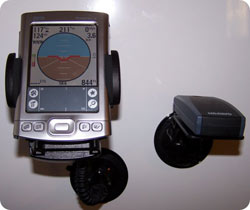 Features of the AeroPalm Aviation GPS include flight planning, fuel planning, weight and balance, flight plan form for calling the FAA, E6B calculations, moving map with airports, airspace including special use and MOAs, obstacles, and nav aids. Also included is a proximity page, HSI, altitude, ground speed, vertical speed and an attitude approximater, as well as an emergency GO-TO function to direct you to the nearest airport in the event of an emergency.
It is available either as a complete Aviation GPS package or separately as a software on Palm handhelds and Treos as well as the Garmin iQue 3600, 3200, and 3000 and most other Palm OS Devices. The solution also works on the newly released Treo 700p.
For those already owning a device, packages are available that include the GPS and mounting hardware for most Palm based PDAs. For those that already have a Palm PDA, the software is available for $149 USD. The complete AeroPalm Aviation GPS starts at less than $535.00 USD.
Article Comments
(11 comments)
The following comments are owned by whoever posted them. PalmInfocenter is not responsible for them in any way.
Please Login or register here to add your comments.
RE: 'Fly by FrankenGarnet'? No Thanks!!!
Tim
I apologise for any and all emoticons that appear in my posts. You may shoot them on sight.
Treo 270 ---> Treo 650
RE: 'Fly by FrankenGarnet'? No Thanks!!!
Soon to be getting a T|X ( or maybe T5, Lifedrive or Treo - I can't decide!)
RE: 'Fly by FrankenGarnet'? No Thanks!!!
RE: 'Fly by FrankenGarnet'? No Thanks!!!
-------------------------------
PocketFactory, www.pocketfactory.com
Elitist Snob, www.elitistsnob.com
Been reliable for me
- Jon
RE: Been reliable for me
You have provided a balanced critique of this product compiled from your first hand experiences.
It helped to push the image of this website away from tabloid towards a respected institution.
RE: Been reliable for me
In fact, I'm thinking of running a nukulur reaktur off of my 700p (if it ever gets past this perpetual white screen here........).
RE: Been reliable for me
The critical periods in a flight are the take offs and landings. Only a fool would be looking at the navigation tools available to a pilot when taking off or landing, whether it is a map, a gps, a vor needle, or I'm sure I'm missing something.
Lets see, the navigation tools available to a pilot include the following. Look out the window, call a flight center and get flight following. They can direct me to any airport by using radar and my transponder, Look at the sectional map that I am required to carry. Use the vor (a directional radio for navigation purposes). When flying it is very important to have multiple forms of navigation for redundancy purposes. GPS navigation is a wonderful tool that helps increase situational awareness to the pilot but backup forms of navigation are important also.
I failed to note previously that I also used the software in my car for 60 - 70 hours also.
I've only had my private pilot rating for about a year and a half. I have to say it has been one of the most saticfying things I ever set out to learn how to do.
Best Regards,
Jon


Latest Comments
- I got one -Tuckermaclain
- RE: Don't we have this already? -Tuckermaclain
- RE: Palm brand will return in 2018, with devices built by TCL -richf
- RE: Palm brand will return in 2018, with devices built by TCL -dmitrygr
- Palm phone on HDblog -palmato
- Palm PVG100 -hgoldner
- RE: Like Deja Vu -PacManFoo
- Like Deja Vu -T_W
'Fly by FrankenGarnet'? No Thanks!!!
Now this is a scary thought!
Freeze and reboot at 6,000 feet?